
Baja Sur Advances Conservation Protection Against Poachers with New Radar Deployment and Community Officers

The M3 Radar is a mobile radar that can be transported to different areas for protection across the marine protected area.
Global Conservation Leads Anti-Poaching Compliance Initiative
On the eastern coast of Baja California Sur, Global Conservation, with the support of local partners and donors, has successfully deployed three M2 Marine Monitors across the San Basilio Bay, Bahía de Loreto National Park and through the Loreto/La Paz marine corridor (the first Marine Monitor Mobile), near the fishing refuges, including communnities such as Agua Verde and San Cosme.

Working in partnership with CONAPESCA, who are responsible for designing and managing public policies on fisheries and aquaculture, GC engages with local citizens who become Community Gaurdians in an effort to protect their natural resources. Meetings like this one reveal information about recent poaching activities.
GC Projects Director of these areas, Alejandro González, is spearheading initiatives to work with local communities to protect the biodiversity found in the stunning underwater ecosystems of Mexico. And by working with private landowners, they can place mobile M3 radar stations to survey for poachers in protected marine areas. The private landowners will also engage with other communities to spread the word about good fishing practices to prevent fishermen from fishing in the wrong areas and prevent bycatch.

Mobula rays face challenges from both high-seas fisheries and entanglement. Manta rays cannot swim backwards and must constantly swim forward to transfer water over their gills, hence they are frequently caught and imprisoned in fishing and mooring lines. When the line snags on their body, gill slits, jaws, or cephalic fins, they execute backward rolls and turns in an attempt to free themselves. Unfortunately, this frequently leads to additional complications.
As part of our Global Marine Parks Defense, we have strategically installed an innovative, technological tool that acts as a fully off-grid autonomous system which facilitates remote surveillance, understanding nautical activities, detecting illegal fishing, and recreational activities in the southern area of the Bahía de Loreto National Park, the fishing refuges, and the remote islands of the protected area.


The M3 allows the detection and recording of nearby vessels with a high degree of accuracy throughout tracks that contain information such as duration and position over time through an integrated radar/long range camera system and AIS signals. Additionally, it generates data such as images of vessels entering its range and loitering patterns. With an off-grid power system and real-time data transmission, its main advantage is strategic mobility, as well as enabling remote monitoring for a variety of users, authorities, and community guardians.
This tool has proven to be not only a technological advantage, enabling us to comprehend nautical and fishing activity in the southern part of the National Park, but also a valuable instrument for the fishing surveillance committees of the cooperatives based in Agua Verde and San Cosme communities. These committees have expressed interest in expanding their monitoring capabilities by incorporating such tools into their network of fishing refuges.

Turtle egg poaching is also a concern for GC’s authorities. It’s not only the water that’s protected, but the land as well. Daily patrolling across multiple protected areas guarded by GC reveals the extent of poachers efforts.
By comparing the level of information provided by vessel tracking platforms such as Skylight and/or Global Fishing Watch, it is possible to understand at a regional level how marine activity is connected and impacted along the corridor from Loreto to Espiritu Santo Island, recognizing that the southern area of the Bahía de Loreto National Park is a key point for the fishing communities within its area of influence.

The M2/M3 radars are capable of capturing live images of vessels a few miles out form the coastline.
We have also gained insight into fishing activities that occur both inside and outside the protected natural area, as well as within two of the largest fishing refuges in Mexico, to assist the authorities in conducting EarthRanger and SMART patrols. We can confirm that the level of detail in the southern part of the National Park surpasses those platforms, primarily due to the M3's ability to detect all types of vessel activity through radar, AIS, and camera. This represents a superior level of detail when it comes to identifying specific vessels or recording those that are regularly present in the area.

Jointly with Loreto National Park ranger, the fisheries officer (CONAPESCA) inspected a fisherman and explained to them about the marine zones that they are allowed to fish in and not fish in. Education for the public (without jumping to quick judgement) is incredibly important for building understanding and trust with local communities.
The Mobile Marine Monitor, supported by park rangers at Bahía de Loreto National Park, fisheries officials, and local partners, is a powerful tool for collecting information on vessel loitering, identifying potential areas of interest through heat maps (illegal fishing), identifying legal fisherman and boats, establishing peak activity times and days, and supplementing knowledge of activities in the area. It also allows us to interact with new interested users, such as legal and organized fishers from the villages surrounding the National Park, and start a discourse about potential collaborations.
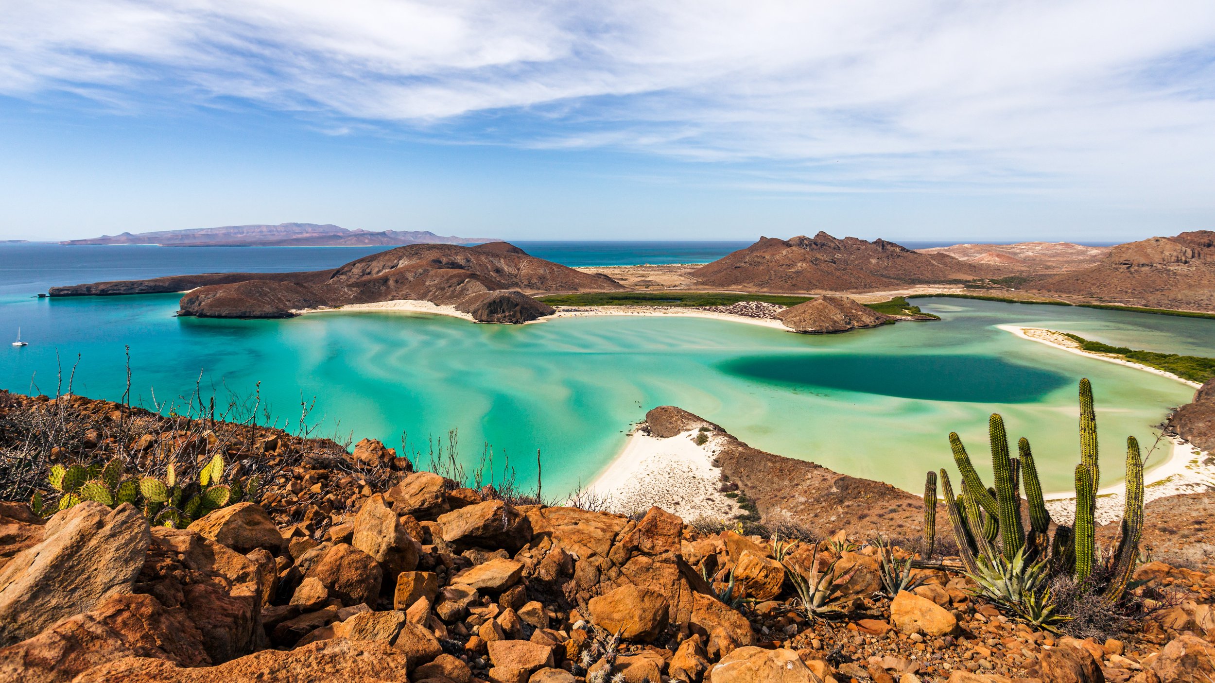


Patrolling marine protected areas means surveying the open waters, coastlines, and the land itself, including the many islands of Baja Sur and the Gulf of California.
Patrolling, though, is potentially dangerous. Cartels often fund poaching looking for specific species that are valuable on the black market, like critically endangered totoaba, fish that are valuable because of their bladders which are used in fake Chinese medicines. Projects Director Alejandro looks to partner with the Mexican Navy, Police, and other governmental officers to protect the GC team, rangers, and officers from poachers while on patrol.
Just a few weeks before writing this, North of our project areas, two officers were kidnapped and another murdered. Although not part of GC, anticipating possibly lethal changes coming to our project areas, it is essential to partner with governmental entities for protection.


Fishermen must acquire a permit for fishing and only in specific zones. When poachers are caught, if their catches are still alive, like the brown clams pictured above, they will be forced to release them back into the wild while under the supervision of our officers. Then, of course, they are warned and/or fined.
As ever, Global Conservation stays motivated to halt poaching in Mexico.


